
World · taz · · 3h
Satellite images of Gaza updated: Google Maps shows the devastation in Gaza
Deutsch (original) · Auto-translated to English
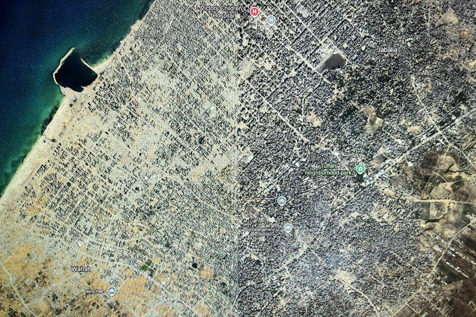
Google Maps has updated its satellite images of the Gaza Strip. They show the extreme extent of the destruction in Gaza caused by Israel's attacks, which began after the Hamas attack on October 7, 2023. The latest recordings are from January and February 2026, others are from last year - depending on the region. But they were apparently only published in the last few days.
Anyone with the Google Maps app can now see for themselves how advanced the destruction was at the beginning of this year. Entire areas of land practically no longer exist. Where a mosque, a football field or a restaurant is marked as a pin on Google Maps, the satellite image only shows rubble.
According to a UN report earlier this year, 200,000 tonnes of explosives were dropped by the Israeli military on Gaza in two years. It goes on to say that this corresponds to the energy equivalent of 13 Hiroshima atomic bombs.
The Palestinian refugee camp Tel al-Sultan was located in the south of the Gaza Strip. The last time the images on Google Maps showed the condition of the place was in May 2024, shortly before the Israeli military bombed the tent camp from the air, also in May 2024. At that time, according to the Palestinian Authority, almost 30 people were killed in the camp near Rafah. Since then, further attacks have followed. Where there were tents and shelters before the bombing, the updated images on Google Maps only show remains.
The destruction of recent years can also be clearly seen in the photographs of Gaza City. Before the Israeli attacks that followed October 7, about 650,000 people lived in the city. According to a report by the UN Satellite Center (UNOSAT), about 83 percent of buildings had been damaged by October 2025.
In some places, Google Maps has not yet updated the satellite view. In Gaza City, from a bird's eye view, you can see a line that runs vertically through the city. In the western part, the photos are from July 2025, in the eastern part from December 2024. While at the beginning of December 2024 there were at least a few more buildings standing - the rubble is already clearly visible here too - a few months later, practically no houses can be seen anymore. Tents can be seen among the ruins. This shows how quickly the Israeli military attacked the city in the north of the Gaza Strip.
Even though Google has only now updated its satellite images, even the most recent ones are only from the beginning of the year. Other companies offer daily updated satellite images, some for free. Like NASA. But they often have poorer resolution. In addition, Google Maps is easier to access for many more people than the satellite image providers used by journalists or experts.
The approximately 2 billion monthly users of Google Maps now see the extent of the destruction in the Gaza Strip a little closer to reality. Other commonly used navigation apps such as Apple's maps app have not yet followed suit.
Ultimately, the updated Google map shows what was already known: the humanitarian situation in the Gaza Strip is dramatic. Since October 2023, more than a million Palestinians have been on the run. In a statement from August 2026, UN authorities assume that the destruction of buildings in the Gaza Strip has increased by another 9 percent since the porous ceasefire agreement in October 2025. In total, Unosat analyzed using satellite images that a total of more than 201,290 buildings in the Gaza Strip were damaged. This corresponds to 82 percent of the entire infrastructure. Two thirds of them were completely destroyed.
Read the full story at the source
Source: taz